IN THIS ARTICLE
Georeference Level Component
The Georeference Level component allows you to choose the geographical location of your simulation. This component is a level component and should be added to the level entity. If you are using, for example, the GNSS Sensor Component, it complements its functionality.
Provider
Dependencies
None
Properties
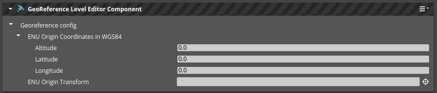
| Property | Description | Values | Default |
|---|---|---|---|
| Altitude | The elevation of the ENU origin entity above Earth’s WGS84 ellipsoid | meters | 0 |
| Latitude | The north-south geographical coordinate in WGS84, where north is positive | degrees | 0 |
| Longitude | The east-west geographical coordinate in WGS84, where east is positive | degrees | 0 |
| ENU Origin Transform | Entity that has a geographical location assigned, and its local coordinate system follows ENU (East-North-Up) directions | Entity |
Usage
- Identify a location in your level with a known geographical position. This could be a corner of a building or an intersection of roads.
- Create an empty entity in known location.
- Rotate the entity so that its local coordinate system aligns with mapping:
- X should point East.
- Y should point North.
- Z should point up.
- In the Georeference Level component, enter the geographical location of the entity and set the ENU Origin Transform to reference the entity mentioned above.